


gtj 3

yvesconnes
User
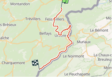

Length
24 km

Max alt
983 m

Uphill gradient
669 m
Km-Effort
34 km

Min alt
494 m

Downhill gradient
934 m
Boucle
No
Creation date :
2024-08-10 07:34:12.873
Updated on :
2024-08-10 20:04:27.532
6h42
Difficulty : Very difficult

FREE GPS app for hiking
 SityTrail
IGN / Geographical institutes
SityTrail Plus
The world is yours!
About
Trail Walking of 24 km to be discovered at Bourgogne-Franche-Comté, Doubs, Les Plains-et-Grands-Essarts. This trail is proposed by yvesconnes.
Positioning
Country:
France
Region :
Bourgogne-Franche-Comté
Department/Province :
Doubs
Municipality :
Les Plains-et-Grands-Essarts
Location:
Unknown
Start:(Dec)
Start:(UTM)
343476 ; 5240378 (32T) N.
Comments